And now for something slightly different. I hadn’t really planned to make this post, but there were recent questions about the Stafford-area bus network on Facebook, and I was doodling in Google Earth and got inspired; if I were given a free hand to redesign the bus network on this side of Brisbane, how would I do it?
I’ve thrown out the existing network, and started from scratch, for two reasons. Firstly, a bus network reform should be providing transport for a better Brisbane of tomorrow, whereas all our existing services were designed for a Brisbane long gone – some are literally the old tram routes from a century ago. And secondly, any proposal to tweak the existing network will always attract overwhelmingly negative feedback, because the people who don’t use it don’t care, and the people who do use it, by definition, find utility in the status quo and don’t want it changed.
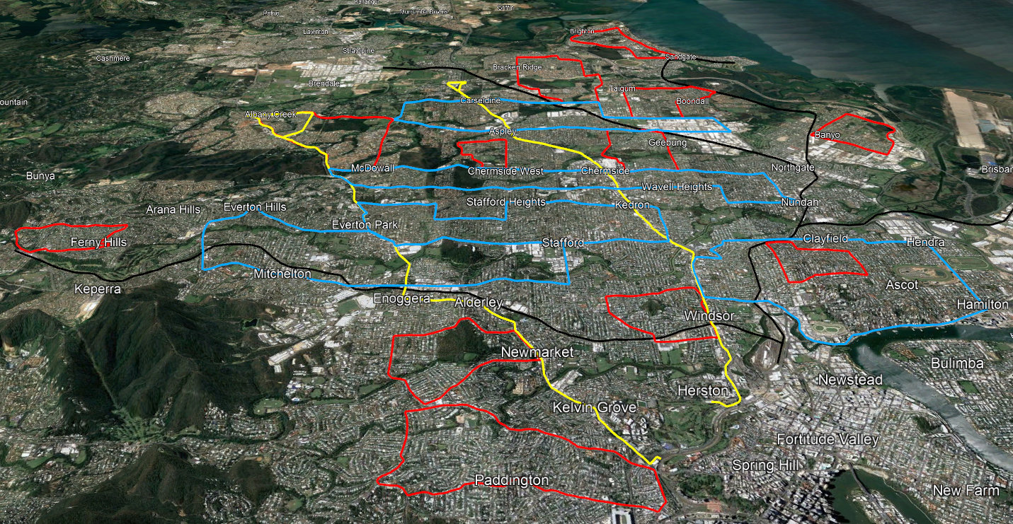
My 19 routes include only two trunk lines that connect to the Brisbane CBD (or, at least, to the Inner Northern Busway / Brisbane Metro), shown on the map in yellow. There are also five cross-town loops, in blue, and twelve local loops, in red. If you’d like to have a look at the map in more detail, you can view it on Google Maps here.

The two yellow trunk lines run the entire length of Gympie Road, from Linkfield Road at Carseldine, through Chermside and the Northern Busway; and along Old Northern Road from Albany Creek, through Everton Park, Enoggera and Newmarket to the Busway at Kelvin Grove – approximately the current 357 route, including the inner part of the 345. What these two routes would do when they reach the busway I’ve left undetermined; they could run to the Cultural Center, as most routes do now, or perhaps they could connect together through Herston into one big “U”, with passengers for the city transferring onto the Metro.
These services should, of course, be very high frequency; they are really the ersatz railway lines through the north west, as well as operating as the north-south connectors for the cross-town loops. I haven’t included any commuter services along Sandgate Road to the east, as they would simply be duplicating the railway lines, highlighted on the map in black.
Cross-town loops, in blue, would operate with high-frequency service – at least every 15 minutes, 7am to 7pm, 7 days a week – in both directions. They are the main backbone of the local transport network; designed not so much for peak-hour commuting, as to allow people to get around their extended neighbourhood easily without being car dependent. They follow major east-west roads and pass within easy walking distance of schools, shops, railway stations, and other useful activity centres.

The first two loops are centered on Stafford Road at Everton Park. The first goes out to Arana Hills along Pullen Road, then back along Samford Road through Mitchelton, and up Pickering St to the Grange. The second travels through Stafford Heights along Flockton, Trouts, Redwood, Appleby and Kitchener Roads, crosses Gympie Road and comes back along the entire length of Stafford Road.
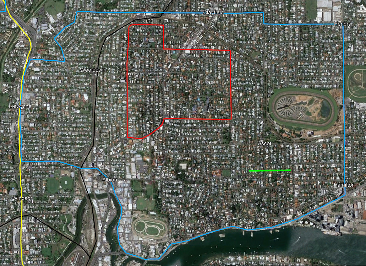
The third cross-town loop connects Albion and Hamilton along Kingsford Smith Drive, up Nudgee Road to Hendra, and across Junction Road to Clayfield and Eagle Junction. It also contains a smaller, local loop around Clayfield, shown here in red.
Local loops provide access to local amenities, as well as providing feeder service to railway stations or other bus lines. Like the cross-town loops and trunk lines, these services are only really useful if they’re high-frequency and run across all times of day – at least every 15 minutes, 7am to 7pm, 7 days a week – but in some cases may only run in one direction. One direction loops get bad press from some transit writers, but in this case the loop is small enough – and fast enough, because we’re still sticking to major roads and straight lines! – that the travel time will be short enough either way, and uni-directional service can achieve twice the frequency with the same resources.
Before we discuss the rest of the local loops, here are the final two cross-town lines:

These are longer services, as we get further out from the CBD, and simply follow the major east-west connecting roads: Rode Road and Hamilton Road between McDowall and Nundah; and Beams/Zillmere and Albany Creek/Robinson Roads between Bridgeman Downs and Virginia.
While these cross-town services intersect the Gympie Road trunk at Westfield Chermside and the Aspley Hypermarket respectively, I’m not proposing they should use the interchanges that currently exist at these locations. Bus interchanges are extremely inefficient, as they require buses to make a number of low-speed maneuvers, and share car park entrances and exits with large volumes of car traffic; and they don’t make much sense unless you have multiple routes terminating in a single location, which is a concept this network design is trying to get away from.
We’ve already seen the first local loop at Clayfield; here are the rest.
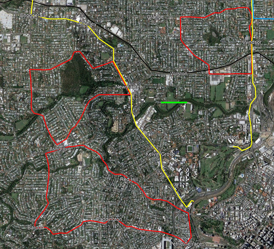
- Paddington/Bardon/Ashgrove/Red Hill; this is a larger and probably bi-directional loop.
- Newmarket/Enoggera/Ashgrove, via Banks St, Wardell St and Ashgrove Avenue.
- Windsor/Wilston, via Kedron Brook Road and Maygar St.

- Brighton/Sandgate, providing local service and connecting to Sandgate railway station.
- Boondal/Taigum, connecting to Boondal station and the Zillmere Road cross-town.
- Bracken Ridge/Fitzgibbon, connecting to Carseldine Station and Beams Road.
These three are all larger, bi-directional loops. While the primary purpose is that they make it easier to get around the local community, all three serve a secondary purpose as railway station feeder services for commuters, as an alternative to parking a car at the station.


- Aspley Hills, via Maundrell Terrace and Horn Road.
- Geebung/Chermside, via Murphy and Newman Roads.
- Albany Creek/Bridgeman Downs/McDowall, via Beckett and Albany Creek Roads.
There’s a big gap in the cross-town loops between Hamilton Road and Robinson/Albany Creek Road. These local loops help bridge that gap.
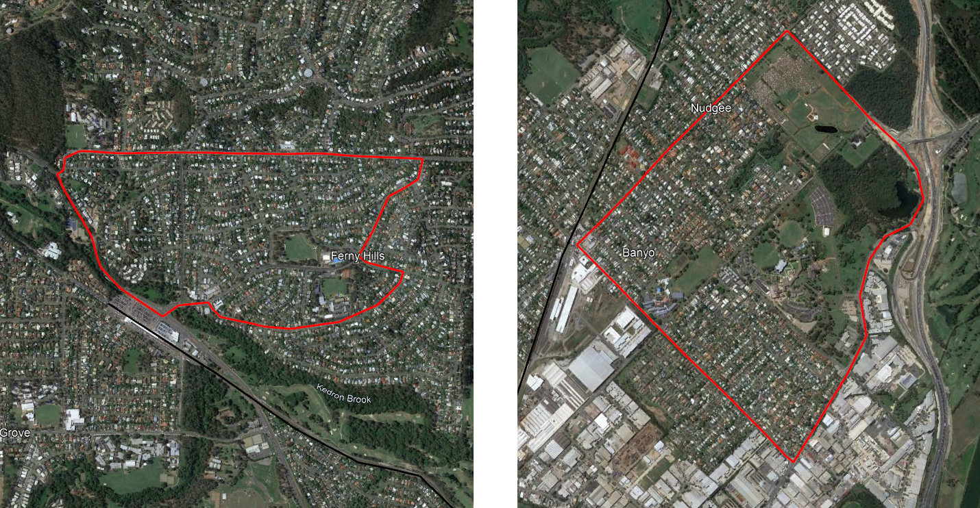
Finally, we have station feeder loops at Ferny Hills and Banyo/Nudgee. These are pretty borderline services, as the roads in these suburbs are not straight or well-connected and the density is low, but they do connect at least one or two local shops and schools in addition to the station. Nonetheless, these one-directional loops do need to be run at high-frequency to ensure that they’re useful to the community, and not just to peak-hour commuters.
So, what would be the advantage of a bus network like this?
The current public transport network in South-East Queensland is entirely focused on moving peak-hour commuters into the Brisbane CBD. For buses, this means that, in peak hour, they’re all stuck in traffic, or running empty counter-flow; while outside peak, much of the fleet sits idle in the depot. This all adds up to an inefficient use of what are very expensive public assets.
On the other hand, as Greater Brisbane continues to grow towards a city of 3 million+ people, the old “fried egg” model of a rich, functional center surrounded by bland, unserviced suburban sprawl becomes more and more unsustainable – but commuter-centric public transport, like commuter-centric arterial roads and freeways, just reinforces the old paradigm. If we’re going to make a shift away from suburban sprawl and towards a functional 21st century city (or cities), we’ll need to reform public transport to support that change.